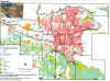
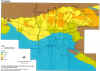
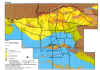
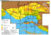
IRAN  [ Back to Microzonation Country list ]   [ Back to Country Index ]
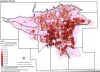
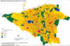
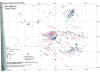
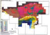
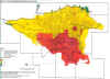
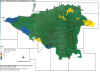
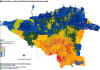
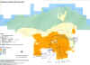
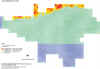
Microzonation
(1) Study Area (2) Topography (3) Geology (4) Groundwater Table (5) Populated Density

studyarea_1_1_1.jpg (578074 バイト)

geology.jpg (567546 バイト)

groundwater.jpg (622096 バイト)

p_density.jpg (418099 バイト)

(6) Building Distribution by Structure (7) Epicentral Distribution (8-1) Model Ground for Seismic Analysis (8-2) Model Geological Log (9) Source Fault Model for Scenario earthquake

b_distribution.jpg (464152 バイト)

a_8.jpg (326294 バイト)

b_2.jpg (559562 バイト)

fig_326.jpg (396924 バイト)

b_3.jpg (326777 バイト)

(10) Seismic Intensity distribution Map (NTF model) (11) Seismic Intensity distribution Map (Mosha fault model) (12) Heavily damaged or Collapsed building ratio distribution (13) Liquefaction Potential (Ray fault model) (14) Slope Stability

b_8.jpg (523927 バイト)

b_10.jpg (476930 バイト)

c_6.jpg (523395 バイト)

c_22.jpg (389618 バイト)

c_23.jpg (305071 バイト)

Data source :
THE STUDY ON SEISMIC MICROZONING OF THE GREATER TEHRAN AREA IN THE ISLAMIC REPUBLIC OF IRAN
By Japan international cooperation Agency (JICA), Center for earthquake and environmental studies of Tehran (CEST), Tehran Municipality