7. Assessment of building damage due to ground failure
Ground failure, for example, slope collapse, can be induced by strong ground motion due to a large earthquake nearby. If there are some buildings in that area, the buildings can be seriously damaged by ground failure.
In this chapter, we introduce some assessment methods of building damage due to ground failure, which includes slope collapse and ground failure on the filled-land developed for housing lots in hilly areas.
7.1.Tokyo Metropolitan Disaster Prevention Council (1991, 1997)
(1)Input/Output
(2)Outline of the Method
The assessment by this method is carried out for "Dangerous area for steep slope failure" in Japan. "Dangerous area for steep slope failure" in Japan is selected by local government based on following standard
a) Height of slope: more than 5 m
b) Inclination of slope: more than 30 degrees
c) The Number of buildings in the range where buildings suffer from slope collapse: more than 5 houses or more than a public building
Tokyo Metropolitan Disaster Prevention Council (1991) established following assumptions to assess the damage.
a) Collapse starts up from the top of the slope.
b) Collapsed earth and sand reach to the distance which is equal to the height of the slope.
c) Collapsed height is equal to a half of the slope height.
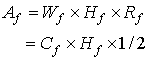
d) The area of slope collapse is given as follows.
![]() : The area of a slope collapse
: The area of a slope collapse
![]() : The width of a slope
: The width of a slope
![]() : The height of a slope
: The height of a slope
![]() : The collapse area ratio
: The collapse area ratio
![]() : The width of a slope collapse
: The width of a slope collapse
![]()
The collapse area ratio means the rate of collapsed slope area to all slope area.
The number of damaged buildings is given as follows, when the distribution of buildings in the range, where buildings suffer from slope collapse, is assumed to be uniform.
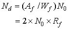
![]() : The number of damaged buildings
: The number of damaged buildings
![]() : The number of buildings in the range where buildings suffer from slope collapse
: The number of buildings in the range where buildings suffer from slope collapse
The collapse area ratio of the area, where peak ground acceleration is 300gal, is given as the value of 2.1 % by Sorimachi (1978). The value is based on the investigation of slope collapse in Kawazu-cho, Shizuoka Prefecture due to the 1978 Izu-ooshima-kinkai Earthquake.
Therefore, the number of damaged buildings in the area where peak ground acceleration is 300gal is obtained by following relationship.
![]()
The building damage ratio for the area, where peak ground acceleration is less than 300gal, is given as shown in Table 7.1.1. This table is shown in the report of Tokyo Metropolitan Disaster Prevention Council (1997), and obtained by using the slope collapse ratio which is based on the investigation of slope collapses due to four past earthquakes by the Fire and Marine Insurance Rating Association of Japan (1994).
Table 7.1.1 Relationship between peak ground acceleration and building damage ratio due to slope collapse (Tokyo Metropolitan Disaster Prevention Council, 1997)
|
Acceleration |
50-100 gal |
100-200 gal |
>200 gal |
|
Slope collapse ratio |
3 % |
11 % |
29 % |
|
Building damage ratio |
0.4 % |
1.5 % |
4.0 % |
(3)Note
The application of this method is limited to the area nearby "Dangerous area for steep slope failure" which is selected by local government in Japan.
(4)Reference
Fire and Marine Insurance Rating Association of Japan (1994) Shamen kyu-keishachi no zisin ji no houkai higai ni kansuru kenkyu, Research Report for Earthquake Insurance No. 37 (in Japanese. Webmaster translates the title "Study on collapse of slopes and steep slopes induced by earthquake").
Sorimachi, Y. (1978) Jisin ni yoru shamen-higai no jittai, Civil Engineering Journal, 20-12, 628-633 (In Japanese. Webmaster translates the title "Study of slope collapses caused by earthquakes").
Tokyo Metropolitan Disaster Prevention Council (1991) Tokyo ni okeru chokka zisin no higai soutei ni kansuru chousa houkokusho, higai soutei shuhou hen (In Japanese. Webmaster translates the title "Study on assessment of earthquake damage in Tokyo, Volume for method description and countermeasure suggestion").
Tokyo Metropolitan Disaster Prevention Council (1997) Tokyo ni okeru chokka zisin no higai soutei ni kansuru chousa houkokusho, higai soutei shuhou hen (In Japanese. Webmaster translates the title "Study on assessment of earthquake damage in Tokyo, Volume for method description and countermeasure suggestion").
7.2.Shizuoka Prefecture Office (1993)(1)Input/Output
(2)Outline of the Method
Fire and Marine Insurance Rating Association of Japan (1992) investigated the damage in the filled-land for past earthquakes, and proposed that the building damage ratio in the filled-land developed for housing lots in hilly areas is 4.65 times as large as non-filled land. The assessment is done based on this ratio as follows.
![]()
![]()
![]() : Building damage ratio in the filled-land developed for housing lots in hilly areas
: Building damage ratio in the filled-land developed for housing lots in hilly areas
![]() : Average building damage ratio due to ground motion in the area of 1)
: Average building damage ratio due to ground motion in the area of 1)
![]() : The number of the existing buildings in the filled-land developed for housing lots in hilly areas
: The number of the existing buildings in the filled-land developed for housing lots in hilly areas
![]() : The number of damaged buildings in the filled-land developed for housing lots in hilly areas
: The number of damaged buildings in the filled-land developed for housing lots in hilly areas
![]() includes the average building damage ratio due to ground motion. So the building damage ratio due to ground failure is
includes the average building damage ratio due to ground motion. So the building damage ratio due to ground failure is
![]() (
(![]() ).
).
(3)Note
This method is used only for the assessment of wooden or LGS (Light Gauge Steel) houses. Therefore, it is not always compensated that this method can be applied to the damage assessment of buildings with other structural type.
(4)Reference
Fire and Marine Insurance Rating Association of Japan (1992) Jinko jiban ni okeru jisin higai ni kansuru kenkyu, Research Report for Earthquake Insurance No. 33 (in Japanese. Webmaster translates the title "Study on earthquake damage on the filled-land developed for housing lots").
Shizuoka Prefecture Office (1993) Dai-2-ji jisin-higai-soutei-kekka hokokusho, an, jinteki / butteki-higai-hen (In Japanese. Webmaster translates the title "The second report of earthquake damage assessment about human loss and material damage, draft").