Past damaging earthquakes near
the epicenter
Table 1 shows 8
events near the epicenter of the
Figure 1 shows 94 events registered in “Catalog of Damaging
Earthquakes in the World” on Google Earth (the search conditions are “latitude:
30-40 degrees” and “longitude: 90-102”).
“Catalog of Damaging
Earthquakes in the World” was compiled by Prof. Tokuji Utsu
and now are maintained and updated by the IISEE, BRI.
Table
1: The events chosen from the earthquake catalog, “Catalog of Damaging
Earthquakes in the World”, under the conditions “latitude: 32-35 degrees” and “longitude:
95-98 degree”.
|
Year |
Month |
Day |
Time |
Latitude |
Longitude |
Depth |
M |
Dead |
Injured |
Damage |
Remark |
|
1738 |
12 |
23 |
- |
33.3 |
96.6 |
- |
6.5 |
115 |
229 |
seve |
|
|
1834 |
- |
- |
- |
33 |
97 |
- |
5.5 |
- |
- |
some |
|
|
1886 |
3 |
0 |
- |
32.5 |
98 |
- |
7 |
- |
- |
some |
|
|
1896 |
- |
- |
- |
32.5 |
97.9 |
- |
7 |
some |
- |
some |
|
|
1896 |
3 |
14 |
- |
32.5 |
98 |
- |
7 |
5 |
- |
|
|
|
1961 |
12 |
4 |
2038L |
33 |
95 |
- |
5.9 |
- |
- |
limi |
|
|
1971 |
4 |
3 |
1249L |
32.2 |
95.1 |
20 |
6.3 |
- |
0 |
limi |
|
|
1971 |
4 |
3 |
1250L |
32.2 |
95.4 |
20 |
6.5 |
1 |
1 |
limi |
|
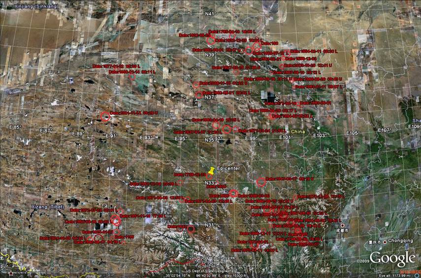
Figure
1: The circles represent 94 events registered in “Catalog of Damaging
Earthquakes in the World” on Google Earth (the search conditions are “latitude:
30-40 degrees” and “longitude: 90-102”). The epicenter of the