Strong Earthquake Motion Observation in Japan
ABSTRACT
The strong motion observation in the field of engineering began in the
1950s in Japan. Professors, researchers and engineers organized a committee
in order to develop the original strong motion instruments and to promote
observation projects and related studies. The steady progress has been
made in the accumulation of valuable records and the improvement in the
instrumental technology.
With the 1995 Hyogo-ken-nanbu Earthquake, which is known as Kobe Earthquake,
the situation of strong motion observation underwent drastic changes. Several
projects were planned and conducted in order to reinforce the strong motion
network. More than 4,000 instruments have been newly placed by national
organizations and municipalities.
On the other hand, Building Research Institute (BRI) is operating three
strong motion networks at present. "Nationwide Strong-Motion Network
of BRI" has 47 observation sites in major cities throughout Japan.
"Dense Strong-Motion Instrument Array in Sendai" is the array
observation that is focused on the amplification effect of surface geology
to seismic motions. "Strong-Motion Instrument Network in the Metropolitan
Area" is a dense instrumental array, which consists of eighteen sites
in the Tokyo metropolitan area. Recent installation was made with more
specific aims, i.e. effect of surface geology, soil-structure interaction,
and other relevant problems to evaluation of seismic input to buildings.
This report generally outlines the up-to-date state of strong motion networks
in Japan. Strong motion observation activities of BRI are also introduced
briefly.
Brief History of Strong Motion Observation in Japan
Japan has often suffered from earthquakes. Major destructive earthquakes
in the twentieth century are listed in Table 1. Figure 1 shows epicenters
of those earthquakes. Any city in Japan cannot escape from earthquake hazards.
The 1948 Fukui Earthquake made researchers realize the necessity to conduct
strong motion observation. Some professors, researchers and engineers organized
the Strong Motion Accelerometer Committee to develop strong motion instruments
in 1951. The prototype instrument was manufactured in 1953 and was named
SMAC from initials of the committee. Specifications of typical instruments
are shown in Table 2. In the early stages of strong motion observation,
most of sites were instrumented and were operated by universities and national
research institutes.
The Strong-Motion Earthquake Observation Committee was established in 1956
in order to maintain strong motion instruments, to process data, and to
publish records. The Committee was mainly operating instruments placed
in buildings, but the expenses were not officially budgeted. In 1965, Strong
Earthquake Motion Observation Center was organized in the Earthquake Research
Institute, University of Tokyo. The Center obtained the certain budget
and took over part of the Committee's task.
In 1967, the Strong-Motion Earthquake Observation Councila) was organized and followed the Committee. The secretariat of the Council
was constituted in the National Research Center for Earth Science and Disaster
Prevention. The Council consisted of representatives of Earthquake Research
Institute (ERI), University of Tokyo, Building Research Institute (BRI),
Public Works Research Institute (PWRI), Port and Harbor Research Institute
(PHRI), Japan Railway (JR), Nihon Telegram and Telephone (NTT), and so
on. The Council still keeps on functioning as the coordinator on strong
motion observation activities in Japan.
Table 1 List of destructive earthquakes in the twentieth century
| # | Date | Epicenter | Lat., Long., MJMA | Casualties |
|---|---|---|---|---|
| 1 | 1923/09/01 | Southern Kanto | 35.1°N, 139.5°E, 7.9 | Dead/Missing: >142,000, Fire |
| 2 | 1925/05/23 | Northern Tajima (Hyogo) | 35.6°N, 134.8°E, 6.8 | Dead: 428 |
| 3 | 1927/03/07 | N.W. Kyoto (Kita-Tango) | 35.5°N, 135.2°E, 7.3 | Dead: 2,925 |
| 4 | 1930/11/26 | N. Izu | 35.1°N, 139.1°E, 7.3 | Dead: 272 |
| 5 | 1933/03/03 | Off Sanriku | 39.2°N, 144.5°E, 8.1 | Dead/Missing: >3,064, Tsunami |
| 6 | 1943/09/10 | Tottori | 35.5°N, 134.1°E, 7.2 | Dead: 1,083 |
| 7 | 1944/12/07 | Off Tokaido (Tonankai) | 33.8°N, 136.6°E, 7.9 | Dead/Missing: 1,223 |
| 8 | 1945/01/13 | S. Aichi Pref. (Mikawa) | 34.7°N, 137.1°E, 6.8 | Dead: 2,306 |
| 9 | 1946/12/21 | Off Nankaido | 33.0°N, 135.6°E, 8.0 | Dead: 1,330 |
| 10 | 1948/06/28 | Fukui | 36.2°N, 136.2°E, 7.1 | Dead: 3,769 |
| 11 | 1964/06/16 | Off Niigata | 38.4°N, 139.2°E, 7.5 | Dead: 26 |
| 12 | 1968/05/16 | Off Aomori Pref. (Tokachi-oki) | 40.7°N, 143.6°E, 7.9 | Dead: 52, Injured: 330 |
| 13 | 1974/05/09 | Off Izu Peninsula | 34.4°N, 138.8°E, 6.9 | Dead: 30, Injured: 102 |
| 14 | 1978/01/14 | Near Izu-Oshima | 34.8°N, 139.3°E, 7.0 | Dead: 25, Injured: 211 |
| 15 | 1978/06/12 | Off Miyagi Pref. | 38.2°N, 132.2°E, 7.4 | Dead: 28, Injured: 1,325 |
| 16 | 1983/05/26 | Central Japan Sea | 40.4°N, 139.1°E, 7.7 | Dead: 104, Injured: 163, Tsunami |
| 17 | 1984/09/14 | E. Nagano Pref. | 35.8°N, 137.6°E, 6.8 | Dead: 29, Injured: 10 |
| 18 | 1993/01/15 | Off Kushiro | 42.9°N, 144.4°E, 7.8 | Dead: 2, Injured: 928 |
| 19 | 1993/07/12 | S.E. Off Hokkaido | 42.8°N, 139.2°E, 7.8 | Dead: 202, Missing: 29, Injured: 305, Tsunami |
| 20 | 1994/10/04 | E. Off Hokkaido | 43.4°N, 147.7°E, 8.1 | Injured: 343 |
| 21 | 1994/12/28 | Far Off Sanriku | 40.5°N, 143.7°E, 7.5 | Dead: 3, Injured: 784 |
| 22 | 1995/01/17 | S. Hyogo Pref. (Kobe) | 34.6°N, 135.0°E, 7.2 | Dead: >5,500, Injured: >30,000 |
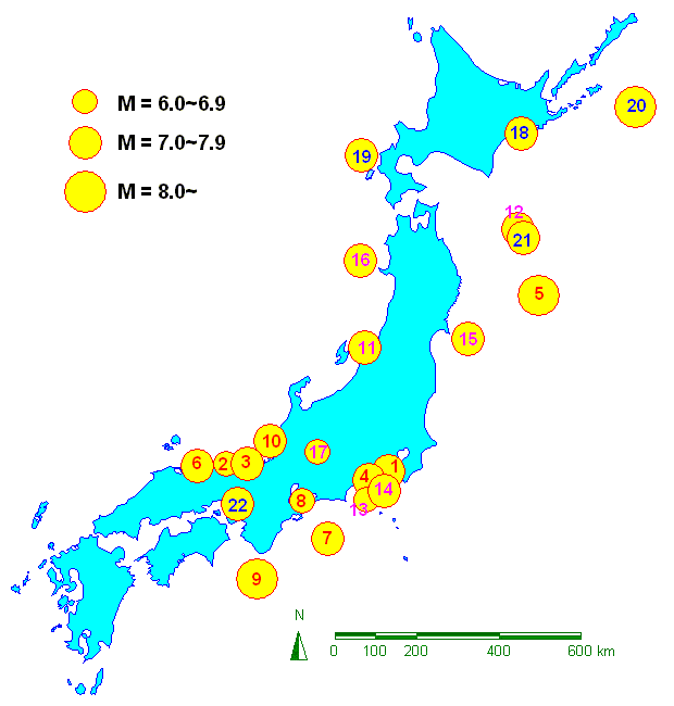
Figure 1 Location of destructive earthquakes in Japan in the twentieth
century
Table 2 Specifications of Typical Strong Motion Instruments
| Model | SMAC-B | SMAC-M | SMAC-MD | SMAC-MDU |
|---|---|---|---|---|
| Sensor | Pendulum | Feedback | Feedback | Feedback |
| Year developed | 1957 | 1972 | 1988 | 1997 |
| Processing system | Analog (Mechanical) | Analog (Electrical) | Digital (16-bit) | Digital (24-bit) |
| Recording medium | Stylus Paper | Cassette Tape | Memory Card | Memory Card |
| Freq. range | DC~10 Hz | 0.1~30 Hz | 0.02~30 Hz | DC~30 Hz |
| Acc. range | ±1000 cm/s2 | ±1000 cm/s2 | ±1000 cm/s2 | ±2000 cm/s2 |
| Sensitivity | 25 cm/s2/mm | 1 cm/s2/mV | 0.03 cm/s2/digit | 0.0025 cm/s2/digit |
| Start level | 10 cm/s2 | 5 cm/s2 | 0.5~32 cm/s2 | 0.1~99.9 cm/s2 |
| Components | 3 | 3 | 9 (max) | 18 (max) |
| Delay time | - | - | 10 sec. | 0~60 sec. |
| Size (W×D×H cm) | 54 × 43 × 37 | 60 × 41 × 17 | 40 × 42 × 21 | 40 × 42 × 21 |
| Weight (kg) | 100 | 23 | 20 | 17 |
Recent Strong Motion Networks in Japan
1. Background
In the light of the tragic disaster of the 1995 Hyogo-ken-nanbu (Kobe)
Earthquake, the Special Measure Law on Earthquake Disaster Prevention (implemented
on July 18, 1995) was passed to protect the people's lives and properties
from disasters caused by earthquakes. According to the law, the Headquarters
for Earthquake Research Promotion was established under the Prime Minister's
Office for unified promotion of earthquake research b).
The Headquarters is comprised of the Director (Minister of State for Science
and Technology) and its staff (Vice-Ministers of relevant Ministries and
Agencies). Under the Headquarters, there are two subsidiary committees,
each is comprised of the staffs of relevant Ministries and those of people
of experience or academic standing, who are conducting the following mandate
concerning to earthquake research.
- Planning comprehensive and basic policies
- Coordinating administrative works such as budgets for relevant bodies
- Formulating comprehensive survey and observation plans
- Collection, arrangement, analysis and comprehensive evaluation of the results of surveys by relevant administrative bodies and universities
- Public relations based on the comprehensive evaluations
On the other hand, the situation of strong motion observation also underwent
drastic changes. Several projects were planned and conducted in order to
reinforce the strong motion network. Japan Meteorological Agency (JMA)
deployed about 600 seismic intensity meters throughout Japan. National
Research Institute for Earth Science and Disaster Prevention (NIED) established
the nationwide network "K-Net" with 1,000 observation sites.
NIED is also constructing another strong motion instrument network "KiK-Net".
Every prefecture equipped the seismic intensity information network system
to concentrate data from all containing municipalities. About 2,600 seismic
intensity meters were newly installed in municipalities that have neither
JMA station nor K-Net station. Those up-to-date networks can gather and
announce the seismic information rapidly.
2. JMA Seismic Intensity Network1)
The Japan Meteorological Agency (JMA) is a unique national agency that
is responsible for tsunami forecasts, short-term prediction of a large
earthquake, and information service on earthquakes, tsunamis and volcanic
activities c). JMA is operating a network made up of about 180 seismographs for continuous
earthquake monitoring and 600 seismic intensity meters covering the whole
of Japan as shown in Figure 2. The Earthquake Phenomena Observation System
(EPOS) at the headquarters of JMA in Tokyo and the Earthquake and Tsunami
Observation System (ETOS) at six District Meteorological Observatories
collect the observational data.
After an earthquake occurs, JMA immediately processes the observational
data and quickly announces information on epicenter, magnitude and the
distribution of seismic intensity to the public through the media as well
as to the disaster prevention organizations. Information from 2,000 seismic
intensity meters, which are set up by local governments, is also compiled
together.
The JMA seismic intensity scale was originally assessed by the human feeling
and the damage examination. In 1996, JMA introduced the new seismic intensity
scale, which can be calculated from acceleration records, and developed
the seismic intensity meter for prompt estimation of the instrumental seismic
intensity. Table 3 provides situation and damage caused by earthquakes
correspondent to the JMA seismic intensity scales. Acceleration data files
are distributed by Japan Meteorological Business Support Center at cost
later on.
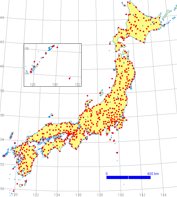
Figure 2 Distribution of JMA seismic intensity meter stations
Table 3 Explanation of JMA Seismic Intensity Scale c)
| JMA Seismic Intensity Scale | Explanation |
|---|---|
| 7 | In most buildings, wall tiles and windowpanes are damaged and fall. In some cases, reinforced concrete-block walls collapse. |
| 6+ (upper) | In many buildings, wall tiles and windowpanes are damaged and fall. Most unreinforced concrete-block walls collapse. |
| 6- (lower) | In some buildings, wall tiles and windowpanes are damaged and fall. |
| 5+ (upper) | In many cases, unreinforced concrete-block walls collapse and tombstones overturn. Many automobiles stop due to difficulty to drive. Occasionally, poorly installed vending machines fall. |
| 5- (lower) | Most people try to escape from a danger. Some people find it difficult to move. |
| 4 | Many people are frightened. Some people try to escape from a danger. Most sleeping people awake. |
| 3 | Felt by most people in the building. Some people are frightened. |
| 2 | Felt by many people in the building. Some sleeping people awake. |
| 1 | Felt by only some people in the building. |
| 0 | Imperceptible to people. |
3. K-Net and KiK-net
National Research Institute for Earth Science and Disaster Prevention (NIED) d), Science and Technology Agency, constructed a large network, which is
called K-Net e), of strong motion instruments in 1996. K-NET consists of 1,000 observation
stations that were deployed all over Japan with spaces of about 25 km.
Each station has a digital strong-motion instrument with a broad frequency-band
and a wide dynamic range on the free field and connects with the control
center in NIED, Tsukuba, through the Integrated Services Digital Network
(ISDN) line. After the occurrence of an earthquake, the distribution of
peak ground accelerations is quickly reported by facsimile and e-mail.
Digital acceleration records are posted on the web site within a few days.
NIED is also deploying the high sensitivity seismograph (Hi-net) and the
digital strong-motion seismograph (KiK-net) f) across the all of Japan, as part of the activities of the Headquarters
for Earthquake Research Promotion. A high sensitivity seismograph and an
acceleration sensor are installed on the firm bedrock at the bottom of
a well. An additional acceleration sensor is placed on the ground surface.
The project plans to construct a network of more than 500 stations, and
about 450 installations have been completed at present. Strong earthquake
motion data are opened on the Internet web server.
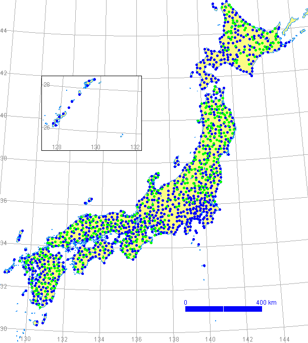
Figure 3 Distribution of K-Net (blue) and KiK-Net (green) sites
4. Seismic Intensity Information Network of Local Governments 2)
The Fire Defense Agency, Ministry of Home Affairs, subsidized local governments
to construct the network system that gathers information on seismic intensity
promptly. The system assists emergency measures and disaster relief activities
by transmitting the information to organizations concerned with disaster
measures. A seismic intensity meter is installed in every municipality
and each local government collects seismic intensities from containing
municipalities. All information finally concentrates at the Fire Defense
Agency. About 200 JMA stations and 500 K-Net stations have been already
placed on the premises of municipal offices. Therefore, 2,600 seismic intensity
meters were newly installed at remaining municipalities. Forty-seven local
governments (prefectures) and about 3,300 municipalities (cities, towns
and villages) are enrolled in this huge network in total. Seismic intensity
scales at a large part of the stations are included in the JMA announcement.
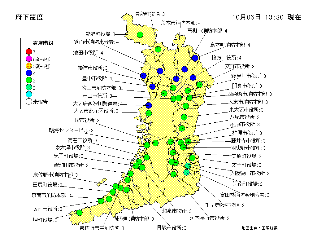
Figure 4 Sample of distribution of JMA seismic intensity scale provided
by the Seismic Intensity Information Network (a case of Osaka Prefecture g))
5. Other National Research Institutes and Public Bodies
(1) Public Works Research Institute, Ministry of Construction h)
Public Works Research Institute (PWRI), Ministry of Construction, is a
national institute in the field of civil engineering. PWRI developed an
essential tool for grasping damage outline immediately after an earthquake
by providing rough estimation on damage of road facilities. The tool, which
is called Seismic Assessment Tool for Urgent Response and Notification
(SATURN), consists of about 700 strong motion instruments placed along
highways and rivers with an interval of 20 to 40 kilometers 3). Peak ground accelerations and spectrum intensities are transmitted to
the headquarters in real-time, and are used to estimate liquefaction possibilities
and damage of highway bridges.
On the other hand, PWRI is operating the Dense Instrument Arrays for Strong
Motion Monitoring in nine sites 4). In order to investigate the seismic effect of geological and topographical
conditions, many accelerometers are three-dimensionally arrayed at each
site. PWRI is also maintaining traditional strong motion observation sites.
The network possesses 1672 instruments at 361 sites and targets dynamic
behavior of bridges, river embankments and dams.
(2) Port and Harbour Research Institute, Ministry of Transport i)
Port and Harbour Research Institute (PHRI), Ministry of Transport, is committed
to researching on broad range of themes concerning ports and harbors as
well as airports by tying-up closely with the bureaus of the ministry in
charge of constructing ports and airports. Strong motion observation of
PHRI has been carried out since 1963, and nowadays observation stations
reach 57 ports including high-density earthquake observation network using
seismic meter distributed intensively in the Haneda Airport and the Kushiro
Airport 6). The results of the observation are periodically reported as the annual
reports and widely used for seismic design and study on earthquake disaster
prevention measures.
(3) Earthquake Research Institute (ERI), University of Tokyo j)
Earthquake Research Institute (ERI), University of Tokyo was a member institute
of the Strong Motion Accelerometer Committee that developed the original
Japanese strong motion instruments, and has long history of strong motion
observation. ERI has deployed strong motion observation stations from southern
Kanto area to Suruga Bay, and densely arranged instruments in the Ashigara
Plain 7) as shown in Figure 5. Observational records are provided on the Internet
web site k).


Figure 5 Location of Observation Stations operated by Earthquake Research
Institute (ERI), University of Tokyo k)
(4) Tokyo Gas Co. Ltd. l)
Tokyo Gas Co. Ltd. supplies gas to customers in the Tokyo metropolitan
area. Tokyo Gas launched development of the Seismic Information Gathering
and Network Alert System (SIGNAL) in 1986 and put it into operation with
331 SI (Housner's Spectral Intensity) sensors in 1994. In addition, Tokyo
Gas commenced preparation of the most extensive ultra-high-density real-time
seismic motion monitoring and disaster mitigation system in 1998. The system,
which is called Super-Dense Real-Time Monitoring of Earthquakes (SUPREME),
will install 3,600 new SI sensors 8).
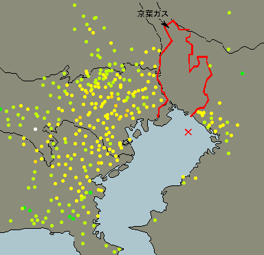
Figure 6 Sample of PGA distribution map posted on the SIGNAL web site l)
(5) Yokohama City m)
Yokohama City, the second largest city in Japan, founded the Dense Strong
Motion Network as a part of the READY (Real-time Assessment of Earthquake
Disasters in Yokohama) system 9). The network consists of 150 ground surface stations and nine borehole
stations distributed at an average interval of 1.7 kilometers. Information
on earthquake ground motions, e.g. peak ground acceleration and JMA seismic
intensity, is transmitted to three centers through the ISDN line within
three minutes. The seismic information is reported to organs concerned
disaster countermeasures and is utilized for damage estimation by READY.
Distribution of seismic intensity is also uploaded to the web site of Yokohama
City m).
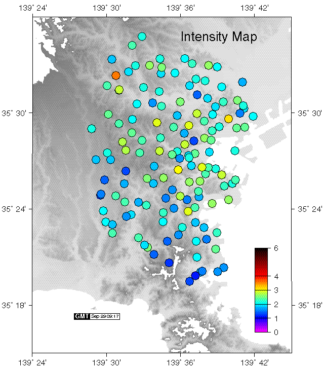
Figure 7 Sample of Seismic intensity distribution map posted on the web
site of Geophysics and Seismology Lab., Yokohama City University n).
String Motion Observation of BRI
Building Research Institute (BRI) o), Ministry of Construction, is a national institute engaging in researches
on architecture and building engineering. BRI has started the installation
of strong motion instruments more than 40 years ago and is now in charge
of three networks p). The aim of the observation is contribution to the enhancement of earthquake-resistant
design technology by means of experimental investigation of strong ground
motion characteristics and building seismic response. Dynamic soil-structure
interaction is also the essential target of observation. Our three networks
and the intensive strong motion installation at BRI are outlined hereinafter.
1. Nationwide Strong Motion Network
The nationwide strong motion network, which has the longest history, has
observation sites in major cities throughout Japan. Forty-seven observation
sites are equipped with digital strong-motion instruments as shown in Figure
8, and connected to BRI through the telephone line. The objects of observation
are mainly buildings, and acceleration sensors are usually placed both
at the top floor and at the basement floor of the building. In addition,
a sensor is also set up on the ground surface at the newly equipped sites.
The network has obtained a number of noteworthy records. For example, in
the 1964 Niigata Earthquake, the change in the characteristics of the seismic
motion caused by liquefaction was clearly recorded in the building next
to the collapsed apartment house in Kawagishi-cho. Also, in the 1978 Miyagi-ken-oki
(Off Miyagi Pref.) Earthquake, acceleration of more than 1,000 cm/s2 was recorded at the top floor of the nine-story school buildings of Tohoku
University. Recently, the peak ground acceleration of 711 cm/s2 was recorded at the Kushiro Local Meteorological Observatory by the 1993
Kushiro-oki (Off Kushiro) Earthquake 10). In addition, in the 1994 Sanriku-haruka-oki (Far Off Sanriku) Earthquake,
an enormous acceleration record was obtained in the building next to the
severely damaged old Hachinohe city hall building 11).

Figure 8 Site location of the nationwide strong motion observation of BRI.
2. Dense strong-motion instrument array in Sendai
It has been considered that the sub-surface layer especially influences
characteristics of the seismic motion acting upon buildings. From 1984
to 1989, eleven observation stations were established on grounds with various
conditions in the Sendai area, under the name of joint research by governmental
and private bodies 12). Each observation station holds three accelerometers, placed on the ground
surface, in the base rock, and in the intermediate layer. Figure 9 shows
configuration of observation stations.
The observation systems of all stations are collectively controlled by
the control center in Sendai City. An NTT exclusive line connects the observation
stations with the control center, and an NTT public line connects the control
center to BRI in Tsukuba. The information on the earthquake records and
the change of instrumental conditions will be sent immediately.
The project as joint research with private bodies has been completed in
1999. BRI reduced the network and updated recording equipment in order
to continue the operation.
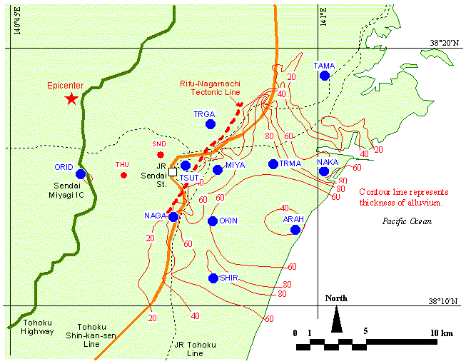
Figure 9 Site configuration of the dense strong-motion instrument array
in Sendai
3. Strong-motion instrument network in the Metropolitan Area
The 1995 Hyogo-ken-nanbu (Kobe) Earthquake awakened us again to the importance
of disaster prevention measures for large-scale urban areas. It is important
to predict the probability of a future earthquake and its impact, and make
as many preparations as possible in anticipation of such an event. It is
also very essential to grasp the damage situation immediately to put in
effect the necessary countermeasures.
In 1996, BRI established eighteen new observation sites that are deployed
radially in the Tokyo metropolitan area as shown in Figure 10. Tokyo stands
on the extremely thick sediment at the center of the Kanto Plan, which
is the largest on in Japan. Therefore, the site configuration was planed
in consideration of the effect of the sedimental layers and the influence
of extensive Kanto Plain on seismic motions. At typical sites, two or three
accelerometers are installed in a building. The system immediately collects
information on the seismic intensities through the telephone line at the
time of an earthquake occurrence.
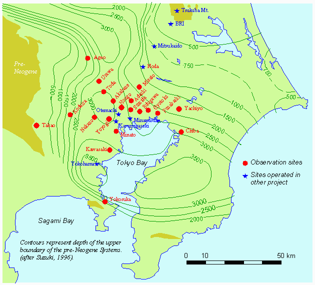
Figure 10 Site location of the strong-motion instrument network in the
Tokyo metropolitan area
4. Strong-motion observation at Urban Disaster Prevention Research Center, BRI
The project to observe the complicated behavior of the building and the
effect of the soil-structure interaction during earthquakes was drafted
with the construction of the Urban Disaster Prevention Research Center
(Annex) building of Building Research Institute, Tsukuba. The installation
was completed in 1998, and the observation is now under way 13).
The annex building has eight stories with single basement floor and supported
by the mat foundation on the clayey layer of 8.2 meters below. The observation
system has eleven sensors in the annex building, seven sensors in the surrounding
ground, and four sensors in the main office building. The farthest sensor
on the ground is placed 100 meters away from the annex building, and the
deepest sensor is set up 89 meters in depth. The amplification process
by the ground surface layers and the three-dimensional behavior of the
buildings are recorded using twenty-two sensors in total. All sensors are
connected to the recording equipment in the observation room in the annex.
The system has 24-bit A-D converters, high-performance digital signal processors
and 40 MB flash memory storage.

Figure 11 Accelerometer configuration at the Urban Disaster Prevention
Research Center, Building Research Institute (BRI)
Conclusions
History of strong motion observation reaches a half of a century in Japan.
The instrumentation technology has been steeply improved and the observation
density has been extremely getting higher. Especially the 1995 Hyogo-ken-nanbu
(Kobe) Earthquake accelerated installation of strong motion instruments
as a principal part of the real-time disaster information system. In such
system, information on the intensity of earthquake motions is gathered
primarily. Peak ground accelerations, JMA seismic intensity scales and/or
SI values are adopted as values representing the ground motion intensity.
Acceleration wave data will be afterwards collected. Characteristics of
recent strong motion instruments and observation work can be summarized
as follows.
- High reliability and broad dynamic range of instruments
- Calculation and display of seismic intensity scale and/or spectral intensity
- Prompt transmittance and announcement of seismic information
- Mutual use of seismic information between different networks
- Rapid publication of digital acceleration data
- Utilization of Internet
However, the most of strong motion instruments, which were expanded after
the 1995 Kobe Earthquake, are placed on the ground surface. Strong motion
observation for structures is also essential to rationalization of seismic
design. More reinforcement of the strong motion observation targeted at
building structures is earnestly expected.
References
Literature
- Doi, Keiji, "Real Time Provision of Earthquake Information in Japan", Proceeding of First U.S.-Japan Workshop on Seismic Information System, 1999, Tsukuba, Japan
- Nagao, Ichiro, "Preparation of Seismic Information Network", Newsletter of Seismological Society of Japan, Vol.10 No.3, 1998 (Japanese)
- Sugita, Hideki, Yasushi Ohtani and Tomofumi Nozaki, "SATURN - Seismic Assessment Tool for Urgent Response and Notification", Proceeding of First U.S.-Japan Workshop on Seismic Information System, 1999, Tsukuba, Japan
- Yokoyama Koichi, Keiichi Tamura, Hideki Sugita, Riki Honda and Akira Chiba, "Dense Instrument Arrays for Strong Motion Monitoring", Civil Engineering Journal, 39-3, Public Works Research Center, 1997
- Sugita, Hideki, "Earthquake Observation of Public Civil Facilities", Newsletter of Seismological Society of Japan, Vol.10 No.1, 1998 (Japanese)
- Ichii, Koji, "Strong Motion Observation at Ports and Airports", Newsletter of Seismological Society of Japan, Vol.10 No.4, 1998 (Japanese)
- Kudo, Kazuyoshi, Kazuki Koketsu, Masayoshi Takahashi and Minoru Sakaue, "Strong Motion Observation of Earthquake Research Institute", Newsletter of Seismological Society of Japan, Vol.11 No.3, 1999 (Japanese)
- Shimizu, Yoshikazu, "Development of SUPREME", Proceeding of First U.S.-Japan Workshop on Seismic Information System, 1999, Tsukuba, Japan
- Saito, Masanori, Susumu Abe and Saburoh Midorikawa, "READY A System for Real Time Assessment of Earthquake Disaster in Yokohama City", Proceeding of First U.S.-Japan Workshop on Seismic Information System, 1999, Tsukuba, Japan
- Kashima, Toshihide, Izuru Okawa and Shin Koyama, "Characteristics of Strong Ground Motions Observed at Kushiro Meteorological Observatory", Proceedings of Eleventh World Conference on Earthquake Engineering (11WCEE), Elsevier Science Ltd., 1996, Mexico
- Kashima, Toshihide, Izuru Okawa and Shin Koyama, "Characteristics of Strong Earthquake Motions Observed at Hachinohe City Hall", 12th World Conference on Earthquake Engineering (12WCEE), New Zealand Society of Earthquake Engineering, 2000, New Zealand
- Y. Kitagawa, I. Okawa, T. Kashima, "Dense Array Observation and Analyses of Strong Ground Motions at Sites with Different Geological Conditions in Sendai", BRI Research Paper, Building Research Institute, July 1994
- Kashima, Toshihide, Izuru Okawa and Shin Koyama, "Earthquake Motion Observation in and around 8-Story SRC Building", NATO Advanced Research Workshop on Strong Motion Instrumentation for Civil Engineering Structures, Kluwer Academic Publishers, 1999, Turkey
Internet Web Sites
- Strong-Motion Earthquake Observation Council: http://www.kyoshin-net.org/kyoukan/
- Headquarters for Earthquake Research Promotion: http://www.jishin.go.jp/
- Japan Meteorological Agency (JMA): http://www.jma.go.jp/
- National Research Institute for Earth Science and Disaster Prevention (NIED): http://www.bosai.go.jp/
- K-Net, NIED: http://www.k-net.bosai.go.jp/
- KiK-Net, NIED: http://www.kik.bosai.go.jp/
- Osaka Prefecture: http://www.pref.osaka.jp/
- Public Works Research Institute (PWRI), Ministry of Construction: http://www.pwri.go.jp/
- Port and Harbour Research Institute (PHRI), Ministry of Transport: http://www.phri.go.jp/
- Earthquake Research Institute (ERI), University of Tokyo: http://www.eri.u-tokyo.ac.jp/
- Strong Motion Array Database, ERI: http://kyoshin.eri.u-tokyo.ac.jp/SMAD/
- SIGNAL, Tokyo Gas Co., Ltd.: http://www.tokyo-gas.co.jp/signal/
- Yokohama City: http://www.city.yokohama.jp/
- Geophysics and Seismology Lab., Yokohama City University: http://www.seis.yokohama-cu.ac.jp/
- Building Research Institute (BRI), Ministry of Construction: http://www.kenken.go.jp/
- International Institute of Seismology and earthquake Engineering (IISEE), BRI: http://iisee.kenken.go.jp/