Kandilli Observatory and Earthquake Research Institute (KOERI), Bogazici University (http://www.koeri.boun.edu.tr/)
Bogazici University is operating a strong motion array (structural and free field)
in and around Istanbul as shown in the figure below.
The records has been collected and opened to public at the
WEB site.
Peak Accelerations
|
Code |
Location |
Latitude, Longitude |
Instrument |
D (km) |
PGA (cm/s2) |
Anchor |
||
|
NS |
EW |
UD |
||||||
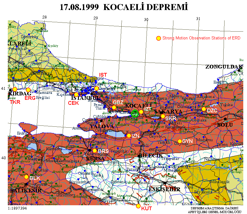
| Earthquake Engineering Division, Earthquake Research Department (ERD), General Directorate of Disaster Affairs, Ministry of Public Works and Settlement (http://angora.deprem.gov.tr/) | ||||||||
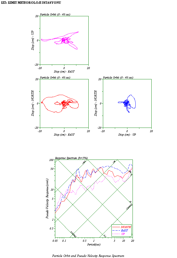
| IZT | Izmit | 40.790°N, 29.960°E | SMA-1 | 10.8 | 167.7 | 220.4 | 143.5 | W, R |
| IZN | Iznik (Bursa) | 40.440°N, 29.750°E | SMA-1 | 31.9 | 90.1 | 120.9 | 80.7 | |
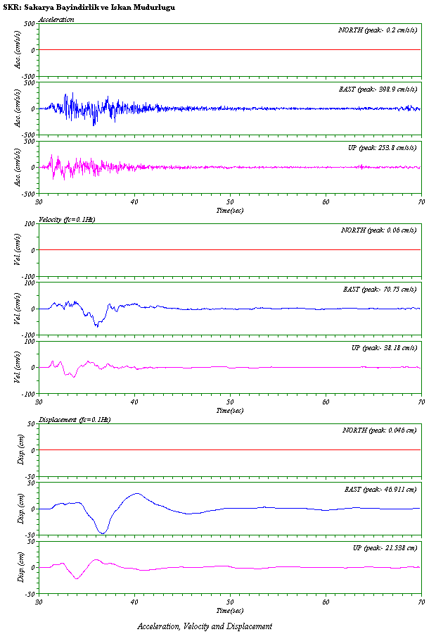
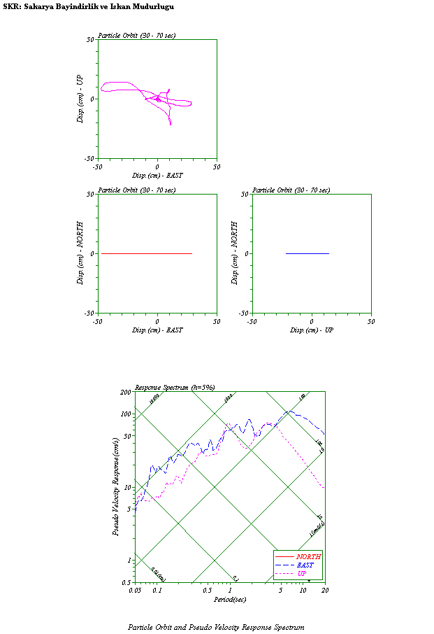
| SKR | Sakarya | 40.737°N, 30.384°E | GSR-16 | 40.1 | - | 398.9 | 253.8 | W, R |
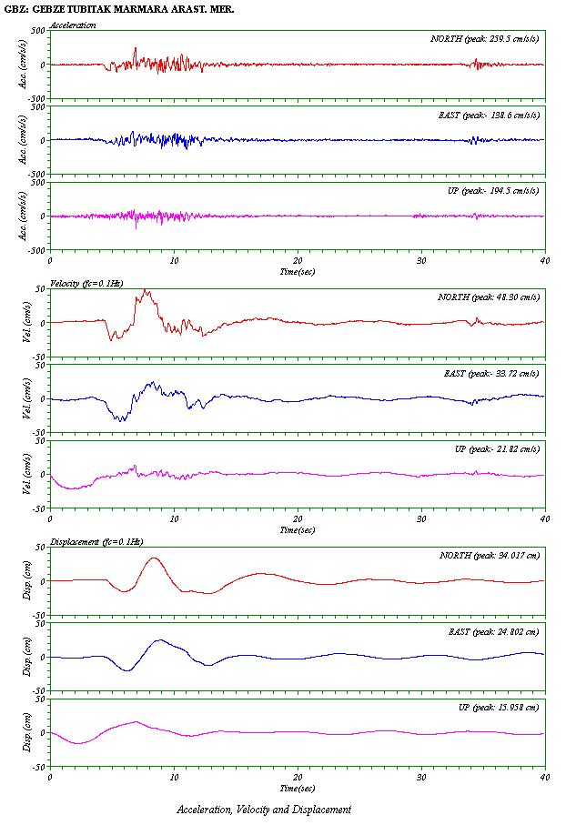
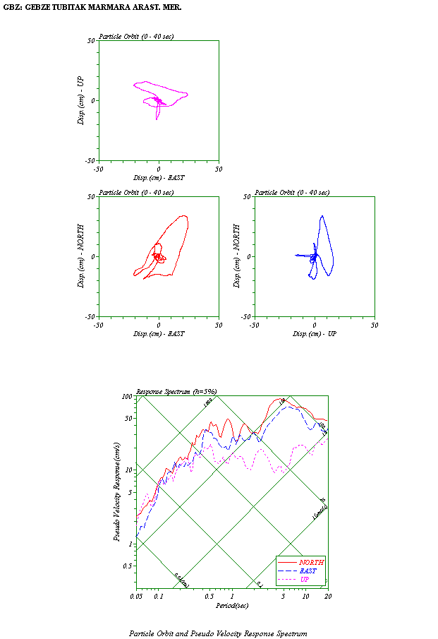
| GBZ | Gebze (Kocaeli) | 40.820°N, 29.440°E | SMA-1 | 41.8 | 259.5 | 138.6 | 194.5 | W, R |
| GYN | Goynuk (Bolu) | 40.381°N, 30.734°E | SMA-1 | 78.1 | 134.9 | 115.5 | 127.3 | |
| IST | Istanbul | 41.080°N, 29.090°E | GSR-16 | 80.9 | 59.5 | 41.8 | 35.5 | |
| BRS | Bursa | 40.183°N, 29.131°E | GSR-16 | 87.5 | 53.2 | 44.9 | 25.2 | |
| CEK | Cekmece (Istanbul) | 40.970°N, 28.700°E | SMA-1 | 106.1 | 115.7 | 87.8 | 48.8 | |
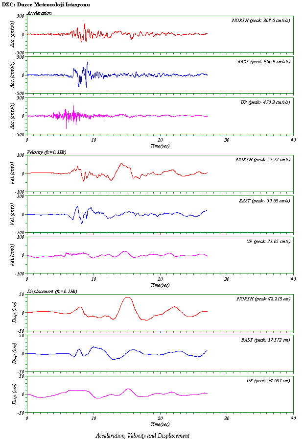
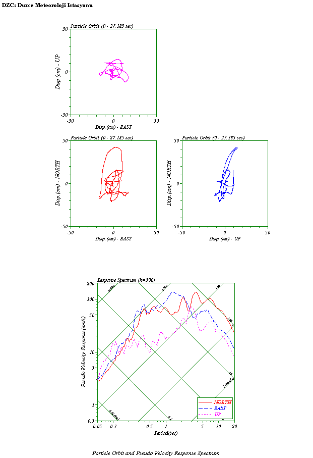
| DZC | Duzce (Bolu) | 40.850°N, 31.170°E | SMA-1 | 107.4 | 308.6 | 366.3 | 470.3 | W, R |
| KUT | Kutahya | 39.419°N, 29.997°E | GSR-16 | 142.6 | 49.0 | 58.5 | 22.8 | |
| ERG | Eregli (Tekirdag) | 40.980°N, 27.790°E | SMA-1 | 181.0 | 88.5 | 99.3 | 55.8 | |
| TKR | Tekirdag | 40.979°N, 27.515°E | GSR-16 | 203.9 | 31.5 | 32.8 | 10.0 | |
| BLK | Balikesir | 39.650°N, 27.860°E | GSR-16 | 209.7 | 17.4 | 17.8 | 7.4 | |
| AFY | Afyon | 38.792°N, 30.561°E | SM-2 | 219.3 | 13.2 | 14.7 | 4.9 | |
| USK | Usak | 38.671°N, 29.404°E | GSR-16 | 229.7 | 11.0 | 14.0 | 3.4 | |
| CNK | Canakkale | 40.142°N, 26.402°E | GSR-16 | 303.4 | 24.1 | 28.1 | 7.8 | |
| MNS | Manisa | 38.580°N, 27.450°E | SM-2 | 316.1 | 12.3 | 6.4 | 4.4 | |
| DNZ | Denizli | 37.812°N, 29.114°E | GSR-16 | 328.4 | 5.8 | 11.5 | 3.6 | |
| BRN | Bornova (Izmir) | 38.455°N, 27.229°E | GSR-16 | 339.3 | 9.7 | 10.6 | 3.3 | |
| TOS | Tosya (Kastamonu) | 41.013°N, 34.037°E | GSR-16 | 348.8 | 11.5 | 8.7 | 4.3 | |
| AYD | Aydin | 37.837°N, 27.838°E | GSR-16 | 364.9 | 5.9 | 5.1 | 3.2 | |
| TKT | Tokat | 40.328°N, 36.554°E | GSR-16 | 563.1 | 0.8 | 1.1 | 0.4 | |
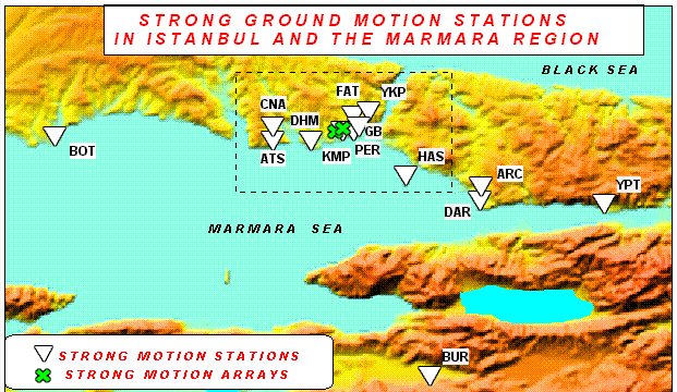
| Kandilli Observatory and Earthquake Research Institute (KOERI), Bogazici University (http://www.koeri.boun.edu.tr/) | ||||||||
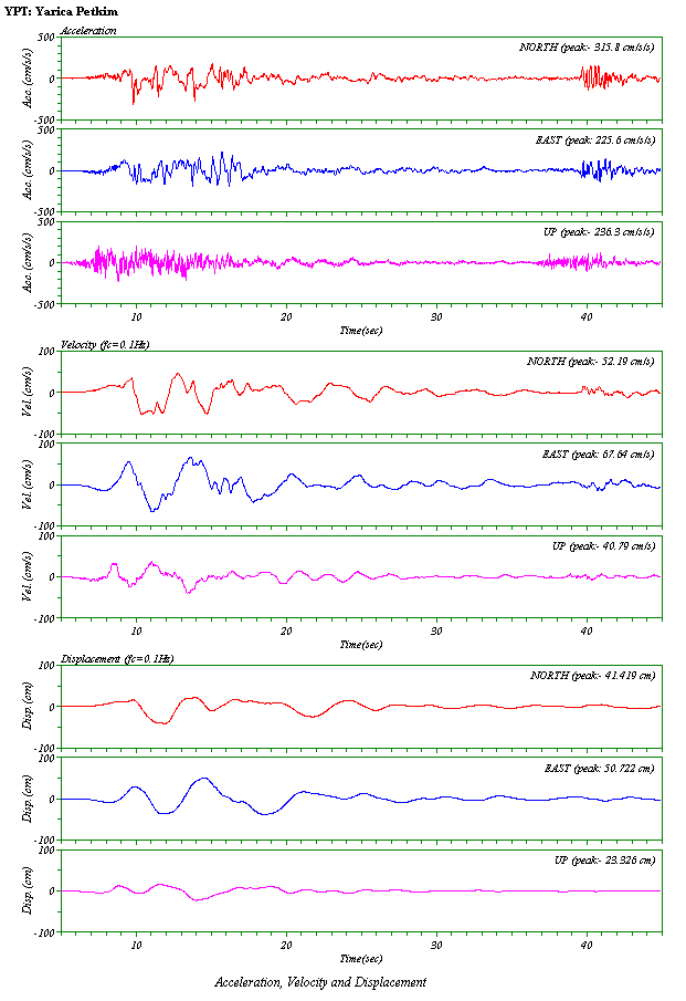
| YPT | Yarimca Petkim | 40.713°N, 29.783°E | GSR-16 | 10.8 | 31.58 | 225.6 | 236.3 | W, R |
| BUR | Bursa | 40.173°N, 29.972°E | GSR-16 | 58.8 | 98.9 | 98.0 | 47.3 | |
| HAS | Heybeliada Senatoryum | 40.869°N, 29.090°E | GSR-16 | 71.6 | 55.0 | 108.0 | 140.6 | |
| YKP | Yapi Kredi | 41.081°N, 29.011°E | GSR-16 | 86.6 | 40.3 | 34.8 | 26.6 | |
| FAT | Fatih | 41.054°N, 28.950°E | GSR-16 | 89.8 | 185.6 | 158.6 | 129.1 | |
| DHM | Hava Alani | 40.982°N, 28.820°E | GSR-16 | 96.9 | 88.4 | 82.8 | 54.0 | |
| CNA | Kucuk Cekmece | 41.252°N, 28.759°E | GSR-16 | 103.4 | 173.8 | 129.4 | 56.5 | |
| ATS | Ambarli Santrali | 40.981°N, 28.692°E | GSR-16 | 107.1 | 247.5 | 182.3 | 78.5 | |
| BTS | Botas Gas Terminal | 40.993°N, 27.979°E | GSR-16 | 165.6 | 85.4 | 96.9 | 23.1 | |
| ARC | Arcelik | ? | GSR-16 | ? | 207.1 | 131.0 | 81.6 | |
|
Epicentral Distance (D) is from (40.70°N, 29.91°E) by ERD.
Unit is converted from (mG) to (cm/s2)
Components are converted from (L, T, V) to (NS, EW, UD)
Click W to see waveforms,
R to see particle orbits and a response spectrum on each row.
All records can be downloaded from those WEB sites.
| ||||||||
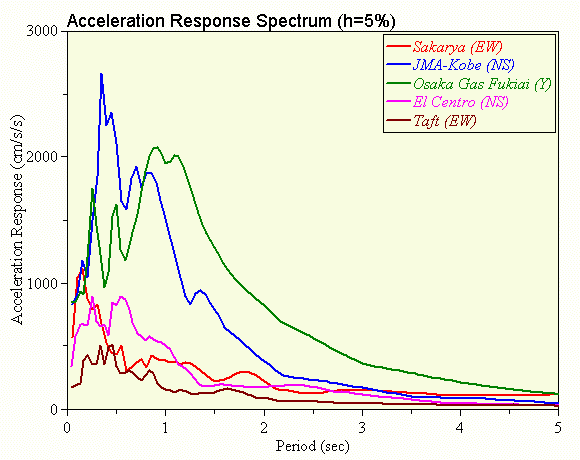
Acceleration Response Spectra
Horozontal componets at sites along the fault
.gif)
Vertical componets at sites along the fault
.gif)
Comparison of spectra at SKR with past large records