M8.1 Kermadec Islands Earthquake of March 4, 2021
Uploaded on March 6, 2021
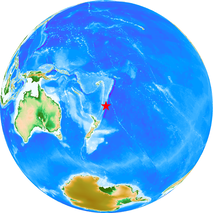
Event
- Event time: 2021-03-04 19:28:31 (UTC, USGS)
- Location: 29.740°S, 177.267°W (USGS)
- Depth: 19.4km (USGS)
- Magnitude: Mww 8.1 (USGS)
Information in our site
Direct links
Related institutions
The epicenter is from the USGS. The land topography and ocean bathymetry are from ETOPO1 (doi:10.7289/V5C8276M).