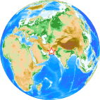
2013/04/16 E of Khash, Iran Earthquake
uploaded on Aplit 17, 2013
updated on Aplit 18, 2013
Mainshock

- Origin time: April 16, 2013 at 10:44:20 UTC (USGS)
- Location: 28.107°N, 62.053°E (USGS)
- Depth: 82.0 km (USGS)
- Magnitude: 7.8 (USGS)
Information in our site
- Determination of earthquake magnitudes using duration of high-frequency energy radiation and maximum displacement amplitudes: application to the April 16, Iran-Pakistan border region earthquake by Dr. Hara
- Aftershock Distribution and the Mainshock’s Fault Plane by the MJHD Method: Application to the Iran-Pakistan Border Region Earthquake on April 16, 2013 by Dr. Hurukawa (Japanese version)
- Iran in IISEE-NET
- Catalog of Damaging Earthquakes in the World (Through June, 2009)
Direct links
- USGS Earthquake Hazards Program (EHP)
- Gosht Earthquake of April 16th, 2013, Iran Strong Motion Network (ISMN), Building and Housing Research Center (BHRC), Iran
- Preliminary Earthquake Report, Iranian Seismological Center, Institute of Geophysics, University of Tehran, Iran
- Last 213 earthquakes, International Institute of Earthquake Engineering and Seismology (IIEES), Iran
Institutions
- United States Geological Survey (USGS), USA
- Incorporated Research Institutions for Seismology (IRIS)
- Iran Strong Motion Network (ISMN), Building and Housing Research Center (BHRC), Iran
- Iranian Seismological Center, Institute of Geophysics, University of Tehran, Iran
- International Institute of Earthquake Engineering and Seismology (IIEES), Iran
Other resources
Copyright © 2013, International Institute of Seismology and Earthquake Engineering (IISEE)
