The 2026 southern Tokachi Earthquake of April 27, 2026
Uploaded on May 7, 2026
Information in our site
Direct links
Related institutions
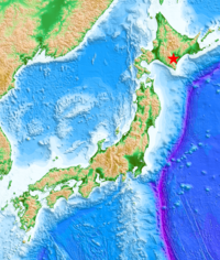
The Generic Mapping Tools (GMT, Wessel and Smith, Eos, 79, 579, 1998) was used to make the figure of the epicenter, which is from JMA (https://www.data.jma.go.jp/eqev/data/daily_map/20260427.html). The land topography and ocean bathymetry are from GEBCO Compilation Group (2020, GEBCO 2020 Grid, doi:10.5285/a29c5465-b138-234d-e053-6c86abc040b9).
©2026, International Institute of Seismology and Earthquake Engineering (IISEE)