
The 2026 Kumamoto Earthquake of July 28, 2026
Uploaded on July 29, 2026
Last updated on August 5, 2026
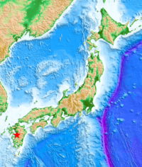
Information in our site
- Strong Ground Motions - 2026 Kumamoto Earthquake on July 28, 2026 (Mj7.1, Mw6.7) [in English](uploaded on July 29; updated on August 5)
- 強震観測速報 (2026年7月28日熊本地震) [in Japanese](uploaded on July 30)
- 熊本県および気象庁の地震観測記録(2026年7月28日熊本地震) [in Japanese](uploaded on August 5)
- Tsunami Simulation - Kumamoto Earthquake on Jul. 28, 2026 by Dr. Fujii (uploaded on July 29)
Direct links
Related institutions
The Generic Mapping Tools (GMT, Wessel and Smith, Eos, 79, 579, 1998) was used to make the figure of the epicenter, which is from JMA (https://www.data.jma.go.jp/multi/quake/quake_detail.html?eventID=20260728163528&lang=en) where the magnitude is shown. The focal depth is from https://www.jma.go.jp/jma/press/2607/28d/202607282030.html. The land topography and ocean bathymetry are from GEBCO Compilation Group (2020, 2020 Grid, doi:10.5285/a29c5465-b138-234d-e053-6c86abc040b9).
©2026, International Institute of Seismology and Earthquake Engineering (IISEE)